The Science Behind Wildfire Behavior

The Science Behind Wildfire Behavior: How Wind and Terrain Impact Fire Spread

The orange glow on the horizon has become an increasingly familiar and frightening sight for communities across the globe as wildfires grow in frequency, intensity, and unpredictability due to climate change and other human-caused factors. Understanding wildfire behavior is no longer just the domain of specialized firefighters and scientists but has become essential knowledge for anyone living in fire-prone regions, which now include areas previously thought to be at low risk. The complex interactions between fire, fuel, wind, and landscape determine how quickly flames spread, which directions they travel, and how intensely they burn through forests, grasslands, and even neighborhoods. Wind and terrain represent two of the most significant factors influencing fire movement, creating conditions that can transform a manageable blaze into an unstoppable inferno within minutes when these elements align in particularly dangerous ways. By examining the science behind how these environmental factors shape wildfire behavior, we can better predict fire paths, develop more effective firefighting strategies, design safer communities, and ultimately save both property and lives in an era when wildfires are becoming increasingly destructive forces of nature.

The Fundamentals of Wildfire Behavior

When experts talk about wildfire behavior, they mean how fires move and burn. This depends on three main factors, known as the “Fire Behavior Triangle“: fuel, weather, and topography.

Fire Behavior Triangle (Wildfire Behavior)

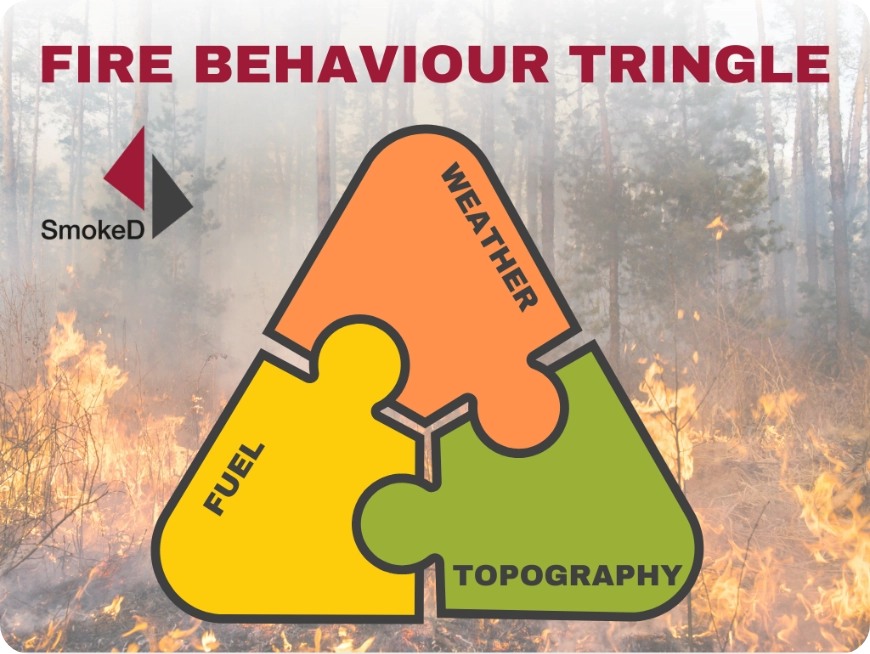
Fuel: Anything that can burn, like trees, grasses, shrubs, or buildings.

Weather: Elements like temperature, humidity, rain, and especially wind.

Topography: The shape of the land, such as hills, slopes, and the direction they face.

These factors interact to create a system where even small changes in one can drastically change how a fire behaves, making each wildfire unique.

Wildfire science builds on the basic idea that heat, oxygen, and fuel are needed for a fire to burn. However, it also looks at how fires spread. Wildfires can move in three ways:

Ground fires: Burn slowly under the surface, like through roots and soil.

Surface fires: Travel along the forest floor, burning leaves, branches, and low plants.

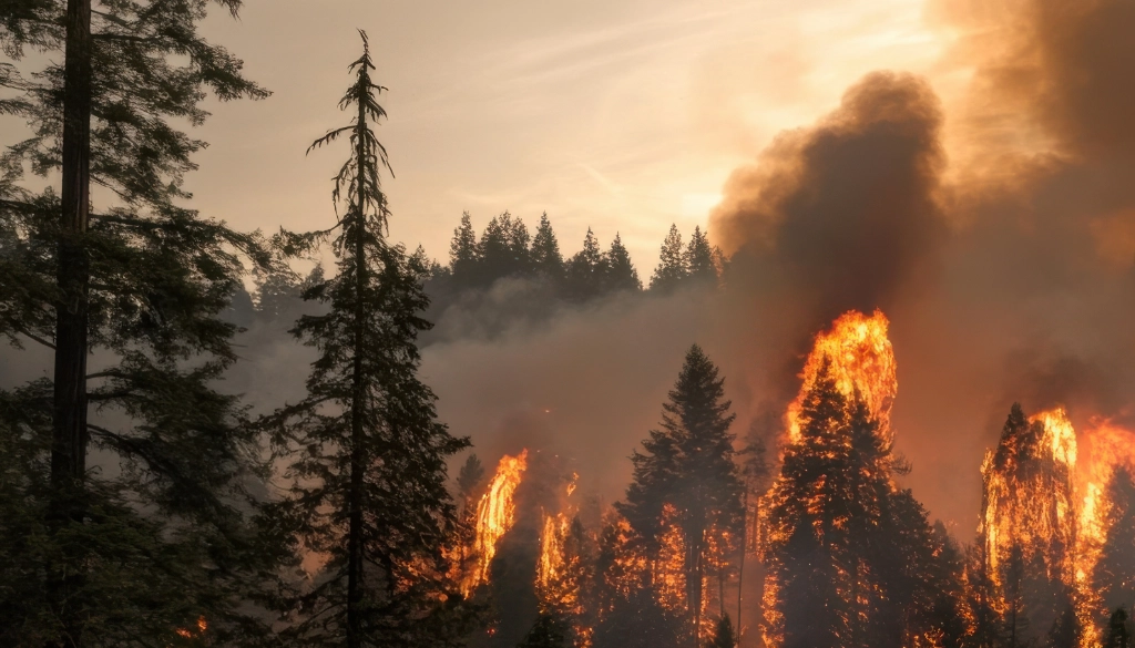
Crown fires: Jump between treetops and spread quickly, making them very dangerous.

The way a wildfire spreads depends on the type of fuel, weather (like wind speed), and terrain features, which can either speed up or slow down the fire.

Fire scientists measure wildfires using:

Rate of spread: How fast the fire moves.

Intensity: How much energy the fire releases.

Flame length: The height of the flames, which helps decide which firefighting methods might work.

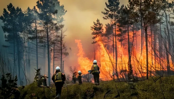
These measurements aren’t just theoretical—they help emergency teams decide when to evacuate, how to allocate resources, and which strategies to use to fight the fire. Understanding these basics is crucial for exploring how specific factors like wind and terrain affect wildfire movement, often with devastating impacts on ecosystems and communities.

The Influence of Wind on Wildfires

Wind is one of the most powerful forces driving wildfire behavior, capable of turning a small, manageable fire into a massive, destructive blaze within minutes. It affects fires in several ways:

Oxygen Supply: Wind fuels fires by adding oxygen, which makes flames burn hotter and spread faster. As fires grow, they can even create their own wind systems that further accelerate their spread.

Spotting: Wind can carry burning embers over barriers like roads or rivers, igniting new fires miles ahead of the main blaze. This creates additional fire fronts, making it harder for firefighters to control the spread.

Certain winds make wildfires particularly dangerous:

Seasonal Winds: Hot, dry winds like California’s Santa Ana and Australia’s westerlies can exceed 40-60 mph, reduce humidity to below 10%, and blow for days. These conditions increase fire risk and make containment difficult.

Examples of wind-driven disasters highlight the importance of forecasting:

The 2018 Camp Fire in Paradise, California, spread faster than a football field every three seconds, driven by strong winds through canyons and slopes.

The 2020 East Troublesome Fire in Colorado grew over 100,000 acres in 24 hours, aided by intense winds.

These examples emphasize why fire meteorologists closely monitor wind patterns and why emergency teams issue evacuation orders when high winds coincide with dry conditions.

Terrain Features That Shape Fire Movement

Terrain plays a major role in how wildfires spread, often speeding up or slowing down their progress.

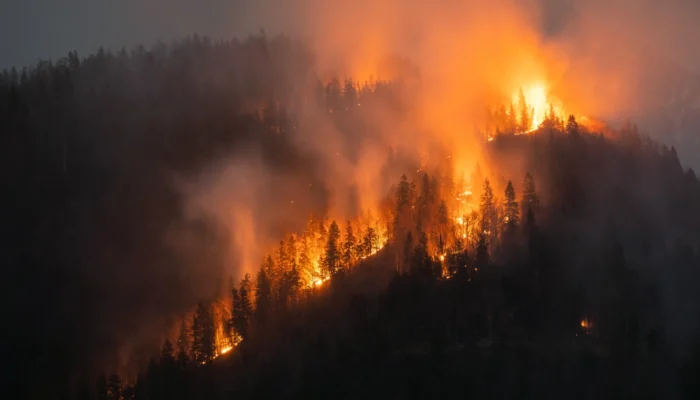
Slope Effect: Fires move much faster uphill than downhill or across flat ground. This happens because heat rises, drying and preheating the vegetation above the flames. This “chimney effect” becomes more intense on steeper slopes, with fire speeds doubling for every 10-degree increase in slope. Steep terrain can make fires extremely dangerous and hard to control, especially in hillside communities.

Aspect (Slope Direction): The direction a slope faces affects how dry and flammable its vegetation is. In the Northern Hemisphere:

  • South and west-facing slopes get more sunlight, making them warmer, drier, and prone to intense burning.
  • North-facing slopes retain more moisture and can act as natural firebreaks.

Valleys and Canyons: These features funnel wind and fire, creating acceleration zones. Box canyons are especially dangerous, acting like chimneys that pull fire upward with intense force. Fires can spread rapidly in these confined spaces, sometimes overwhelming firefighters, as seen in the 2013 Yarnell Hill Fire in Arizona.

Natural and Constructed Firebreaks: Barriers like rivers, rock formations, roads, or cleared vegetation strips can slow fire spread. However, during extreme fire conditions with strong winds, embers can jump over these barriers and ignite spot fires beyond them, making containment much harder.

The Interplay Between Wind and Terrain

Wildfires become most dangerous when wind and terrain work together, creating a powerful combination that accelerates fire spread and intensity beyond what either can do alone.

Alignment of Wind and Terrain: When strong winds blow in the same direction as uphill slopes, fires spread rapidly. The wind feeds the flames while the slope preheats the vegetation above, causing the fire to move dangerously fast. Certain canyons and hillsides are prone to repeated catastrophic fires because of how their shape and direction align with seasonal winds.

Terrain Shapes Wind: Landscape features like mountains, valleys, and ridges influence wind patterns by creating localized airflows. For example:

  • During the day, air heats up and moves upslope.
  • At night, cooler air flows downslope. However, strong regional winds can override these local patterns, creating unpredictable fire behavior.

Microclimates: Wind and terrain create small areas with different moisture levels, temperatures, and fuel conditions. These variations explain why some areas burn intensely while others remain untouched. Burn patterns often reflect these microclimate differences, showing how complex the interaction between wind and terrain can be.

Predicting Fire Spread: Computer models use detailed data on terrain, wind, and fuel to predict how fires will move. While models are improving, challenges remain in accurately capturing how wind flows through varied landscapes and affects fire behavior.

By studying the interaction between wind and terrain, fire scientists aim to better predict and respond to wildfires, helping communities prepare for and adapt to these natural disasters.

Modern Approaches to Predicting Fire Spread

As wildfires become more frequent and intense, scientists have developed advanced technologies to monitor and predict how fires will spread. These tools combine real-time data from various sources to create detailed and accurate forecasts.

Satellite and Aircraft Monitoring: Satellites track fire locations and intensities using heat detection, even through thick smoke. Aircraft equipped with infrared sensors map fire perimeters, showing where flames are spreading the fastest. This data helps emergency teams make quick decisions about evacuations and resource deployment.

Fire Behavior Models: Simulation models like FARSITE and QUIC-Fire use information about fuels, weather, and terrain to predict fire movement. These models include high-resolution terrain data and detailed maps of vegetation, improving their accuracy in forecasting fire progression under different wind conditions.

Remote Sensing Technologies:

  • LiDAR: Maps forest structures in 3D to identify fuel arrangements.
  • Multispectral Imaging: Assesses vegetation moisture levels to locate dry areas prone to rapid fire spread.
  • Thermal Infrared Sensors: Detect hotspots through smoke and track fire perimeters.
  • Specialized Radars: Monitor weather conditions contributing to fire risks.

Despite these innovations, challenges remain. Wildfires are complex and unpredictable, with factors like wind shifts, ember behavior, and collapsing smoke columns creating chaotic conditions that are hard to model. Scientists are working to improve data collection, computer simulations, and mathematical models to make predictions more reliable and help communities better prepare for future fire threats.

Practical Applications for Firefighting and Management

Understanding how wind and terrain influence wildfire behavior directly informs firefighting tactics and strategy, with incident commanders using this knowledge to deploy resources more effectively and safely during fire suppression operations.

Firefighting Tactics:

  • Firefighters often attack the sides of a wildfire (flanks) instead of the fast-moving front (head). This approach is safer and helps slow the fire down gradually.
  • Terrain features like ridgelines or natural barriers are used to set up containment lines in places where fire spread might naturally slow down.

Controlled Burns:

  • Fire managers plan controlled burns during moderate weather to prevent the fire from escaping and spreading uncontrollably.
  • They use natural barriers, like streams or sparse vegetation, to keep flames within safe boundaries.
  • Burns are often started at the top of slopes and work downward to maintain control.

Community Planning:

  • Evacuation routes and home designs in fire-prone areas account for wind and terrain risks.
  • For example, communities in canyons with strong seasonal winds need multiple evacuation paths.

Homes built on steep slopes follow stricter vegetation management rules and use fire-resistant materials like enclosed eaves and non-combustible roofs to withstand wind-driven embers.

Risk Analysis:

  • Detailed maps of terrain and wind patterns highlight high-risk areas.
  • Fire agencies create fuel breaks and place firefighting resources in strategic positions during dangerous weather.
  • Mapping systems predict fire spread rates, giving emergency managers the data they need to issue timely evacuation orders and save lives.

Conclusion

The intricate science behind wildfire behavior continues to evolve as researchers develop more sophisticated tools for understanding how environmental factors shape the movement of flames across diverse landscapes around the world. Wind and terrain have emerged as dominant influences in this complex system, working both independently and synergistically to create conditions that can either facilitate or impede fire spread depending on their specific configurations and alignments during wildfire events. As climate change alters traditional weather patterns and extends fire seasons in many regions, this scientific understanding becomes increasingly valuable for communities seeking to coexist with fire as an ecological process while protecting human lives and infrastructure from its most destructive manifestations.

If you found this article insightful, share it with others! Promoting awareness and understanding of wildfire behavior can empower communities to prepare more effectively and protect their residents and ecosystems.

Also, don’t miss the opportunity to explore SmokeD. We specialize in advanced smoke and fire camera detectors powered by AI and machine learning algorithms, offering cutting-edge solutions for wildfire detection and prevention.

You can learn more here.

Together, we can make a difference in how we understand, prepare for, and coexist with wildfire risks in a changing world.

Picture of SmokeD

SmokeD

Our mission is to increase the level of safety of people and animals living in high-risk areas, which are particularly exposed to fires. By implementing our system, we protect you, your facilities, and the nature that surrounds us. We are happy to cooperate on projects that have a huge positive impact on our planet.

Share post on: